(317) 707-3700 info@banning-eng.com
  • Facebook
  • RSS
  • Facebook
  • RSS
Banning Engineering
  • Home
  • About & History
    • About & History
    • Meet Our Team
    • News
  • Testimonials
    • Clients
    • Team Members
  • Careers
    • Benefits
    • Job Opportunities
    • Online Application
  • Markets
    • Construction Services
    • GIS Services
      • GIS Utility Mapping
      • GIS for Roads
      • GIS for Economic Development
      • GIS for Public Awareness
      • GIS Support
      • GIS Additional Services
    • Economic Development
    • Private Utility Locating
    • Recreation and Quality of Life
    • Site Development
      • Site Development Commercial
      • Site Development Residential
    • Stormwater, Dams and Levees
    • Surveying
    • Transportation
    • Water & Wastewater
  • Civic Engagement
  • Contact
Select Page

Moresville 200 ~ Sammy L. Davis Day & Sammy L. Davis Medal of Honor

Apr 8, 2024 | Civic Engagement, Featured

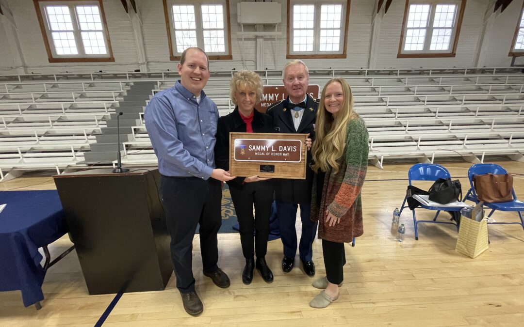
It was a great privilege to present Medal of Honor recipient Sammy L. Davis a commemorative plaque at the Mooresville200 Sammy L. Davis dedication event. What an honor it was to attend and recognize Sammy L. Davis. Thank you to the Mooresville200 team and the Town of Mooresville for organizing such a remarkable celebration. Sammy is a Mooresville High School ’66 alumnus and Medal of Honor recipient. At the event, the Town of Mooresville read a proclamation declaring February 21st as Sammy L. Davis Day. The Town also dedicated and renamed a section of Monroe Street to Sammy L. Davis Medal of Honor Way.

Banning Engineering’s transportation team worked on the road reconstruction of Mooresville’s Monroe Street. Logan Vieck (GIS Mapping Technician) made the personal plaque for Sammy and Dixie Davis. Mark Butler (VP of GIS and Transportation Services), the Monroe Street project manager, and Mary Banning (Business Development Manager) presented the plaque to Sammy and Dixie. Interested in learning more? Read Sammy’s incredible Medal of Honor story below, taken from the Congressional Medal of Honor Society’s website. Be sure to check out all the Mooresville200 happenings on their website as well. A big thank you to those who organized the event, allowed us to participate, and shared photos with us.

For conspicuous gallantry and intrepidity in action at the risk of his life above and beyond the call of duty. Sgt. Davis (then Pfc.) distinguished himself during the early morning hours while serving as a cannoneer with Battery C, at a remote fire support base. At approximately 0200 hours the fire support base was under heavy enemy mortar attack. Simultaneously, an estimated reinforced Viet Cong battalion launched a fierce ground assault upon the fire support base. The attacking enemy drove to within 25 meters of the friendly positions. Only a river separated the Viet Cong from the fire support base. Detecting a nearby enemy position, Sgt. Davis seized a machine gun and provided covering fire for his gun crew, as they attempted to bring direct artillery fire on the enemy. Despite his efforts, an enemy recoilless-rifle round scored a direct hit upon the artillery piece. The resultant blast hurled the gun crew from their weapon and blew Sgt. Davis into a foxhole. He struggled to his feet and returned to the howitzer, which was burning furiously. Ignoring repeated warnings to seek cover, Sgt. Davis rammed a shell into the gun. Disregarding a withering hail of enemy fire directed against his position, he aimed and fired the howitzer which rolled backward, knocking Sgt. Davis violently to the ground. Undaunted, he returned to the weapon to fire again when an enemy mortar round exploded within 20 meters of his position, injuring him painfully. Nevertheless, Sgt. Davis loaded the artillery piece, aimed, and fired. Again he was knocked down by the recoil. In complete disregard for his safety, Sgt. Davis loaded and fired three more shells into the enemy. Disregarding his extensive injuries and his inability to swim, Sgt. Davis picked up an air mattress and struck out across the deep river to rescue three wounded comrades on the far side. Upon reaching the three wounded men, he stood upright and fired into the dense vegetation to prevent the Viet Cong from advancing. While the most seriously wounded soldier was helped across the river, Sgt. Davis protected the two remaining casualties until he could pull them across the river to the fire support base. Though suffering from painful wounds, he refused medical attention, joining another howitzer crew which fired at the large Viet Cong force until it broke contact and fled. Sgt. Davis’ extraordinary heroism, at the risk of his life, is in keeping with the highest traditions of the military service and reflect great credit upon himself and the U.S. Army.

Categories

  • Civic Engagement
  • Economic Development
  • Featured
  • From the Desk of
  • GIS Services
  • Newsletter
  • Private Utility Locating
  • Residential Site Development
  • Survey
  • Transportation
  • Wandering Indiana
  • Water & Wastewater

Recent Posts

  • Wandering Indiana ~ State Capitol, Hendricks Live, & More…
  • ESRI Features Banning Engineering in Transformative GIS Project
  • Jon Polson Accepts ISPLS Board Member Position

BANNING ENGINEERING INC.

853 COLUMBIA ROAD
SUITE 101
PLAINFIELD, IN 46168

PENDLETON OFFICE

200 S PENDLETON AVENUE
SUITE 208
PENDLETON, IN 46064

REACH US

info@banning-eng.com

(317) 707-3700

  • Facebook
  • RSS
Designed and Maintained by C2IT Consulting, Inc.
GIS Mapping for Easement Management

[vc_row][vc_column width=”2/3″][vc_column_text]Wouldn’t it be nice to quickly verify if your utility is within a recorded easement?  Banning offers a powerful solution for utilities and municipalities to manage their utility easements.  We leverage our land surveying staff to create an interactive web-based map showing all the easements across the utility territory.  The user can click on each easement to see details like instrument number, area, and even a picture of the recorded document.  This map can be made available to field personnel through Esri mobile applications for android and iOS devices.

[/vc_column_text][/vc_column][vc_column width=”1/3″][vc_single_image image=”327″ img_size=”full” alignment=”center” onclick=”img_link_large” img_link_target=”_blank”][/vc_column][/vc_row]

GIS for Marketing and Public Awareness

[vc_row][vc_column width=”3/4″][vc_column_text]Banning is in the business of helping clients meet their utility, facility, and economic development needs.  GIS plays a strong role in solving problems internal to the organization.  This same data can often be leveraged to promote, educate, and engage the public.  Banning provides services to host web-based maps, story maps, and even customized mobile apps for a variety of case uses.[/vc_column_text][/vc_column][vc_column width=”1/4″][vc_single_image image=”427″ img_size=”full” alignment=”center”][/vc_column][/vc_row]

GIS Support and Hosting Services

[vc_row][vc_column width=”2/3″][vc_column_text]At Banning, we are committed to developing a solution that works best for your organization.  Are you looking for a way to leverage your staff to collect utility data?  Banning provides services to set up your map templates, guide you on hardware, train your staff for efficient and accurate collection, and provide GIS support and hosting.  This approach is most effective in creating excellent maps even when budgets are limited.[/vc_column_text][/vc_column][vc_column width=”1/3″][vc_single_image image=”417″ img_size=”full” alignment=”center” onclick=”img_link_large” img_link_target=”_blank”][/vc_column][/vc_row]

Utility Asset Management

[vc_row][vc_column width=”2/3″][vc_column_text]Having an accurate system map empowers the utility manager to make data-driven decisions.  With data like pipe age, material, and size a water utility manager can start planning a pipe replacement program.  This approach is common but does not tell the whole story.  Banning engineers can use the GIS system data to quickly create a hydraulic model.  The hydraulic model is a powerful tool to show current system deficiencies as well as performance under future development flows.  This data allows the manager to make pinpoint improvements for the largest system benefit.  The resulting data, mapped in the GIS system, is a powerful visual to graphically show the short and long-term capital improvement plan for your utility.[/vc_column_text][/vc_column][vc_column width=”1/3″][vc_single_image image=”324″ img_size=”full” alignment=”center” onclick=”img_link_large” img_link_target=”_blank”][/vc_column][/vc_row]

GIS Mapping for Utilities

[vc_row][vc_column width=”2/3″][vc_column_text]Have you ever had a late-night main break, but can’t find the shut-off valves?  Is your senior operator about to move on or retire?  Afraid his 30 years of system knowledge will go with him?  These are two common examples of problems utility managers face.  The solution has never been easier or more affordable.  Mobile GIS mapping technology can revolutionize the way you run your utility.  Banning offers map setup, training, GIS support and hosting services for a wide variety of utilities including Water, Wastewater, Storm, Gas and Electric.  Using the latest in cloud-based Esri® Collector mapping technology, let Banning show you how we can:

  • Map your system to the accuracy that’s appropriate for your system and budget
  • Print reports for permitting agencies
  • Link features like valves, power poles and manholes to photos, as-builts, and videos
  • Securely host your map online for mobile device access
  • Leverage viewing and collection apps for use on android and iOS devices
  • Setup inspection layers for routine maintenance tracking
  • Train your staff on collecting and managing the data
  • Prepare your system for SRF funding eligibility
  • Prepare GIS Standards for contractors so the financial burden of map additions is put on developers

[/vc_column_text][/vc_column][vc_column width=”1/3″][vc_single_image image=”323″ img_size=”full” alignment=”center” onclick=”img_link_large” img_link_target=”_blank”][/vc_column][/vc_row]

GIS Maps for Parks

[vc_row][vc_column width=”2/3″][vc_column_text]Facility managers can bring the park inventory struggle to an end by creating an interactive park inventory map.  Feature like benches, playground equipment, or trash receptacles can be located, assessed for condition and photographed.  Adding a layer for an ADA accessibility assessment or for planning a long-term park improvement schedule can be very powerful.  These internal management tools can also be adapted to provide park information outside your organization to the community.  Story maps are a powerful way to educate and encourage park use.      [/vc_column_text][/vc_column][vc_column width=”1/3″][vc_single_image image=”325″ img_size=”full” alignment=”center” onclick=”img_link_large” img_link_target=”_blank”][/vc_column][/vc_row]

PASER Road Rating Maps

[vc_row][vc_column width=”2/3″][vc_column_text]Are you ready to get serious about managing your street network? Since 2016, the Community Crossings Matching Grant through INDOT has required an asset management plan.  Banning can create an interactive map of your street network with each segment color coded by PASER Pavement rating.  More powerful yet, showing multiple years of PASER data can show deterioration trends.  With this data, you can create a long-term capital improvement plan with a powerful visual to show the public and elected officials.[/vc_column_text][/vc_column][vc_column width=”1/3″][vc_single_image image=”326″ img_size=”full” alignment=”center” onclick=”img_link_large” img_link_target=”_blank”][/vc_column][/vc_row]

GIS Planning for Economic Development

[vc_row][vc_column][vc_column_text]Are you looking to give your community a competitive edge?  Draw attention from site selectors with the latest in interactive web maps, drone fly-over videos and 3D renderings for your developing community.   Banning can help create a web-based experience to highlight key features developers are looking for like available utilities, proximity to transportation routes, and topography of the site.[/vc_column_text][/vc_column][/vc_row]